Winter Ascent of
Musala Mountain via North and North West Ridges
 |
| That one at the back |
One minute I'm walking round a well known outdoor shop when a
book catches my eye, 6 months later I'm stood outside the Yastrebets ski lift
station in Borovets, Bulgaria waiting for the first Gondola to take me and my
pal John halfway up a mountain.
The book is Europe’s High Points and for a fairly
inexperienced climber like myself it seemed to be an ideal tick list. After a
3.58 am start the previous day, we'd flown into Sofia, driven about an hour
south to Borovets, checked into our apartment which is really cheap out of
season and then stocked up with food a drink for the following day on the
mountain.
 |
| Research |
 |
| More research |
We had tried to get information on the routes on Musala, the
highest point in Bulgaria, as the book only cites the ‘tourist’ route, and even
under snow, that seemed a little tame. Also, the topography screamed for a
circular traverse. We got a map from Stamfords, but at 50k scale and with 50m
contour intervals, it didn’t give too much away. We posted on UKC and
Summitpost for information, but the best we got was a couple of folk who had
done the traverse in summer and one person from UKC who said it looked ‘tasty’.
That whetted our appetite, and looking at the small pictures on Summitpost, we
adjudged it to be around II/III Scottish, or maybe PD+/AD-, but we were sure it
would have ways around the difficulties if it was so easy in summer. Oh, a
mountaineers optimism eh!?

After an evening researching the route in Borovets, (‘Yeah,
up here along there, do you know it? No? Oh well, another couple of Kamenitzas
then’) we find ourselves at the Yastrebets uplift for the first car of the day.
By 9.20am we're at the top ski station summit at 2396m, it was already clear that the mountains
were going to be deep in snow and with fresh powder in parts. Fortunately an
overnight frost made the downward traverse bearable although crossing the iced
pistes required crampons. An hour later we arrived at the large Musala refuge, (normally
used by pilgrims, as Musala is quite a holy mountain in Bulgaria apparently), closed
at this time of year and deep in snow. We had a decision to make, up and down
the standard route on the west side of the hill, or try to ascend via the
longer North and North East ridge. As the winds were very light and the powder
not too deep we headed for the classic 'summer' ridge route.

Our first target was the obvious coll just below the Ireeek
summit, where there is an interesting rock formation called the Sfinksa
(Sphinx), and it certainly does look like its Egyptian counterpart. Well it
would have been an obvious coll had the cloud not descended halfway up the
climb.
We kept to the right of large crags and found our way around
a small cornice and onto the ridge. From here an upward ridge walk and a few
short scrambles brought us to the summit, navigation was becoming tricky with
the larger scale map as the section before (a section only printed in Cyrillic,
Noeyek, at 2852m) flattened. Finding the ridge again, we roped up and climbed
for an hour to the top of Malka Musala (Little Musala). We'd chosen a 30 m rope
and a half rack, which for this section is more than enough as very little
protection is required, and we weren't expecting major difficulties further on.
 |
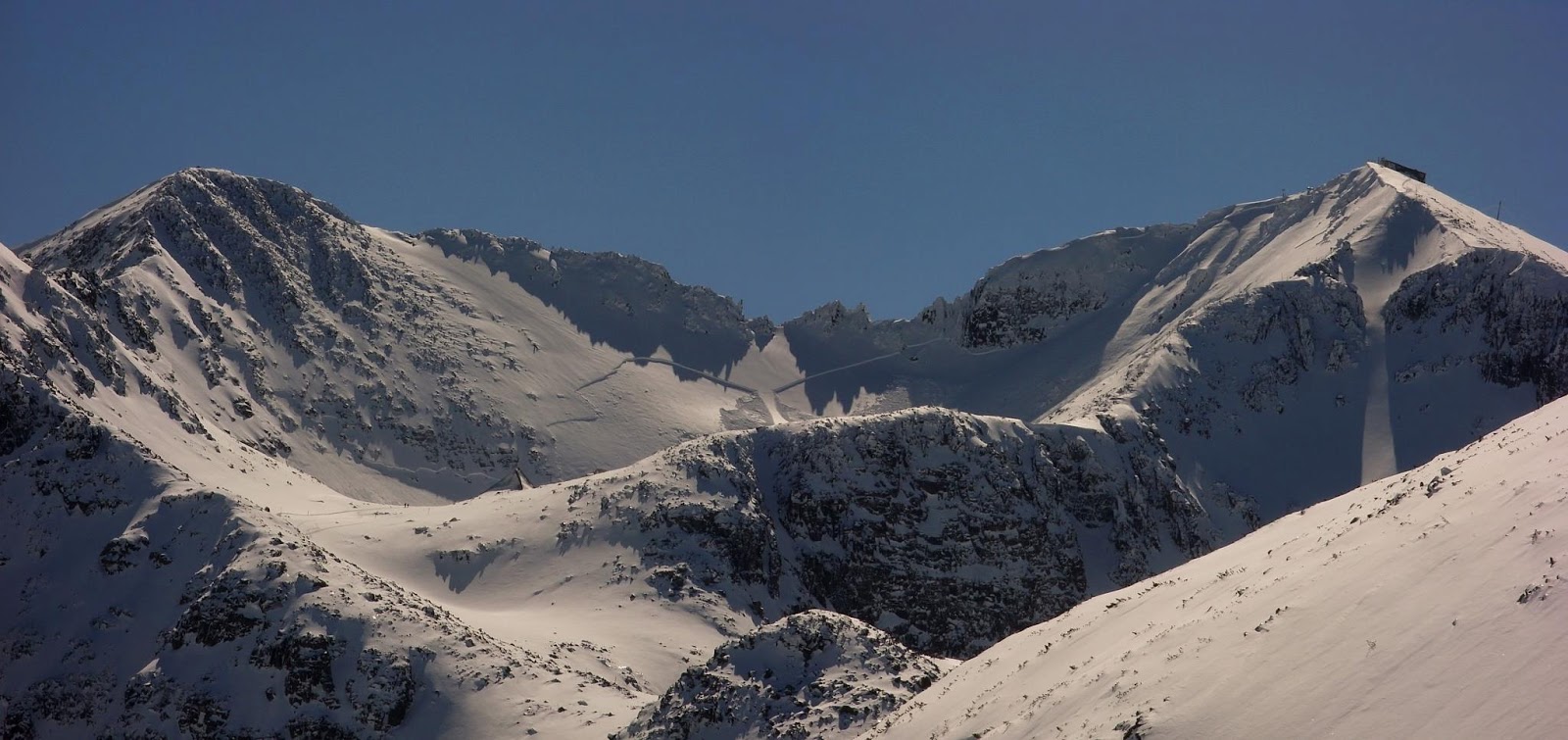
| The day after, you can see the route by zooming in on our footsteps |
Still in the cloud at the summit of Malka Musala a judicious
compass reading was taking to be certain of our downward SSW direction. We were
aware that the next ridge section was likely to be more difficult from the
photographs we'd seen, but what we had underestimated was the combination of
route length and technical climbing in winter conditions. It became clear to us
now at about 2pm that summiting and returning to catch the last lift to
Borovets at 4.15pm just wasn't an option. Fortunately we'd read that the
weather station at the summit is open all year round and offers refuge so that
took the pressure off, and allowed us to just concentrate on climbing safely in
the fresh powder.
 |
| 'On BELAY' |
The climbing quickly became more difficult, the ridges very
narrow and banked with fresh powder, with variable cornices on both sides. My
more experienced climbing partner estimating this long ridge as Scottish Grade
II/III. In between the sections where we could rope and move together we needed
to make about 20 pitches and a 60m rope would certainly have been better. Still
for me as a relative novice the short rope communication definitely helped. We
chose to stick to the crest wherever possible as the powder snow to the side
was deep and on steep ground. We'd already heard a number of distant avalanches
rumbling like thunder across the mountains, and these focused the mind!
 |
| Anywhere off the summit was a tadge steep |
A couple of the pinnacles needed to by bypassed, as the
chimneys were filled with snow and assured footwork was required on extremely
steep ground. The photograph below shows one such section which we avoided by
down climbing an 8m vertical gulley, which was interesting. It was 4 hours of
full on up and down climbing along the ridge now, the really interesting part
being the uncertainty of a route off.
 |
| Plenty of these to negotiate |
Approaching the latter section the weather improved
significantly, on the one hand we were now getting great views of the mountains;
on the other the final upward ridge loomed above us with what looked to be
impossibly narrow ridge sections. Another hour of climbing and we came to what
was hopefully the last obstacle it was now about 7.30pm and we were being treated
to late evening sunshine whilst looking at a long corniced ridge that was going
to be difficult to protect. Nothing for it.....I stood aside and let my more
experienced climbing partner 'route find'! Once crossed, it was clear we were
going to be able to walk off roped together and I was having a major breakout
of elation.
 |
| After you Sir |
We finally arrived at the summit at 8.15pm just as the sun
was setting.
Now all we had to do was find a way into the hut. A full 360
inspection revealed most of it to be inaccessible due to snow, however there
was a small tunnel leading to a likely looking window, and after banging on it
for a while, a firm shove with the back of a walking axe saw it swing open.
 |
| Next morning it's easy to find! |
 |
| Oh Yes :) |
At
least I was going to be inside for the night. Once inside though things
improved rapidly, and Rosen the onsite resident weatherman turned up and
offered us tea and brandy. There was a really toasty bunk room and a drying
area in the kitchen. The meteorologists do one week on and one week off, and
double up as de facto hut guardians when not taking their readings.
 |
| Short journey to work |
 |
| Good man |
 |
| mmmhh Soup |
An hour later, after warnings from Rosen that ‘I have not
seen any British in 15 years here, and any Germans that come here will never
eat our soup’ we were tucking into the local delicacy, tripe soup (I've learnt now
that it's best not to ask and just eat) and sharing whisky. You have to have a
slug of the local whisky (Rakia) before eating the soup...funny that, eh!? My
friend gave him some our Glenlivet, much to his delight. After an hour or so
exhaustion took over and we collapsed on our mattresses, its strange how
difficult sleeping is at altitude, I think it was about 2am before I finally
passed out.
Next morning we were greeted by blue skies and perfect views
all around, time for a few photographs
and a 4 hour walk down the 'tourist'
route to Borovets, as it turned out the cableway doesn’t work on a Monday. The
first section is anything but touristy and a slip here wouldn't be a good idea.
It is protected by cables fixed to posts, a remnant of an old electricity
supply I suspect. The one good thing about long but gradual routes off is they
do tend to be easier on ageing knees. The clear day also gave us the opportunity
to see our footsteps and plot our route accurately from the previous day.
It was almost 11hours walking and climbing to the summit from
the top of the ski lift, we could have moved fast with a longer rope and maybe
taken an hour or so less, but really, why would you want to rush a ridge like
that? It was very Alpine in character, and it is very surprising that we
struggled to find any information on it. Was it the first British winter
traverse!?
 |
| Everest hut - buried in snow |
 |
| Looking back up the valley |
We timed the trip to perfection, as Borovets closed down
that weekend. If you want a bit more life, then go earlier in the season, but
you will have to ignore the ski paraphernalia on your approach, but then John, tells me it’s the same at the Briethorn for example. We had a real
‘out-there’ climb, as we knew mountain rescue was pretty limited, Bulgaria is
really ‘foreign’ as it were, and there was no-one else on the mountain, so we
knew we had to be self-reliant. We did under-estimate it in terms of gear, but
used what we had to great effect, moving slowly but safely and only leaving one
bit of tat on the abseil.
A great weekend, with some great memories


 . Meanwhile Dolly set a new goal of Dove crag for mum and daughter. The views all the way up there were gorgeous.


